Operative
MPD-2047 commenced through Gazette S.O. 4597(E) on 20 August.

September 2026 edition · updated through 13 September 2026
The monthly report separates operative law, official guidance, implementation gaps and supplementary market context in one source-linked view.
September change ledger
Official access has improved materially. Implementation rights have not expanded merely because new guidance, maps, feedback access or reported timelines are available.
MPD-2047 commenced through Gazette S.O. 4597(E) on 20 August.
DDA published MPD-2047 FAQs on 27 August.
Six topic publications were added on 29 August.
Two GIS atlases were added for preliminary screening.
DDA opened MPD-2047 Feedback through Citizen Services.
The 31 August Land Pooling EoW date elapsed; no later extension was located.
DDA published a reference road layer for Zones N, P-I and P-II, expressly subject to change.
A broader three-to-four-month target; not converted into a final notified RNP.
Seven TOD proposals or expressions and a Regulations target; not approvals.
01 · Executive thesis
Gazette notification of MPD-2047 expands the strategic opportunity set. It does not create uniform, immediate development value. The next repricing will be selective.
MPD-2047 is now legally operative; value conversion moves from plan-status uncertainty to regulations, maps, schemes, infrastructure and approvals.
Broad zone narratives will fragment into micro-markets determined by official mapping, access, infrastructure, assembly quality and scheme readiness.
The key question is how existing permissions, Land Pooling applications, sectors and consortiums will be treated under the notified Plan and its implementing directions.
Verified aggregation, clean data, coordinated diligence and authority-ready documentation will command more value than unverified inventory.
Regulatory, infrastructure and market clocks will not advance together. Mispricing emerges when expectations move faster than implementation and execution.
Broad-zone appreciation should never substitute for evidence of legal effect, exact geography, scheme readiness, infrastructure, parcel control and viable economics.
02 · System architecture
A planning headline becomes executable land value only when every gate aligns. A defect lower in the stack cannot be cured by a stronger policy narrative above it.
Notified and commenced controlling instrument
Official map, exact parcel and exclusions
Applicable sector, TPS, TOD, LDA or layout route
Access, trunk services, phasing and agency capacity
Title, contiguity, authority and encumbrances
Charges, obligations, finance, build cost and absorption
03 · Current position
The scorecard is a qualitative DSC assessment across six conversion gates. It shows framework maturity, not parcel eligibility or probability of success.
Gazette-notified and operative; downstream implementation required
New notified Chapter 4.1; Regulations and transition directions awaited
Notified policy and Regulations; scheme-specific execution
Notified controls and village schedule; indicative N/P-I/P-II RNP viewer now available
Notified policy; indicative N/P-I/P-II RNP viewer available, but qualifying stretches and approvals remain
Existing routes; intensely location-specific
The market may capitalise a headline quickly; durable value appears only when lower-level evidence catches up.
04 · August inflection
S.O. 4597(E), published on 20 August 2026, completes Central approval and Gazette commencement. The implementation bridge remains incomplete.
Wording, definitions, schedules and annexures
Approval, notification and commencement
Spatial certainty and zonal preparation
Existing pooling, sector, TOD and LDA pathways
05 · Land Pooling
Chapter 4.1 now governs at Master Plan level; detailed Regulations and DDA directions must connect it to existing registrations, sectors and consortium records.
Owner-led assembly, DDA-led Town Planning Schemes, FAR 200 and a 60:40 scheme model are notified. The 20-hectare threshold applies to an owner-assembled scheme; an eligible owner may participate with any parcel size.
An indicative RNP viewer is now available for N, P-I and P-II, but detailed procedures, final scheme treatment and transition directions remain awaited. The last published EoW date, 31 August 2026, has elapsed.
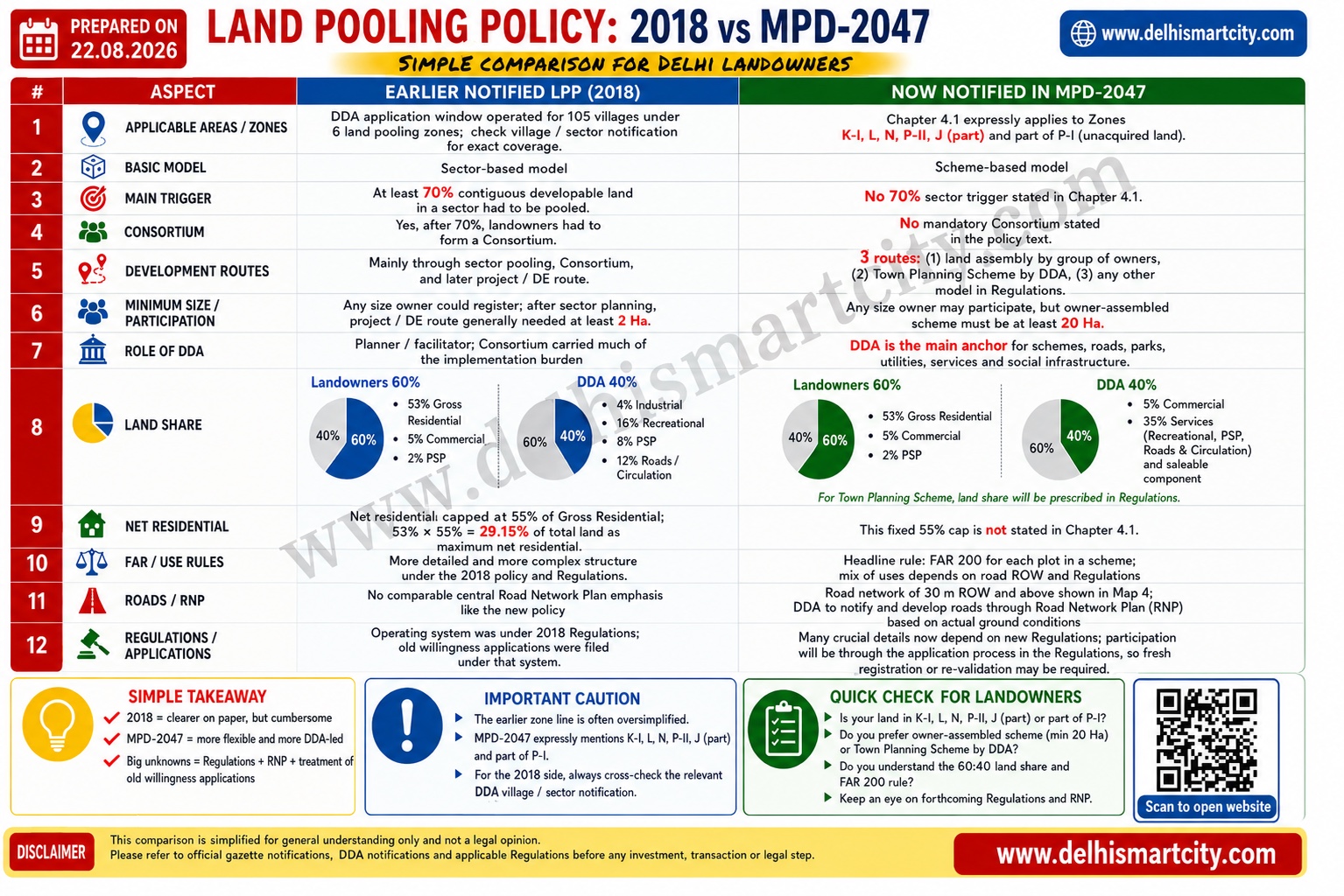
A simplified comparison for orientation. The notified MPD-2047 text, valid Regulations, schemes, maps and approvals remain controlling.
06 · Opportunity regimes
High-value opportunity is not one category. Each regime has a different spatial trigger, assembly logic, cost structure and failure mode.
Village, part-boundary, revenue parcel, access, exclusions, Regional Park/court controls and sanctioned records drive eligibility.
Open LDA intelligence →Influence-zone mapping, consolidated plot, road width, charges, affordable housing, design and approval workflow drive residual value.
Open TOD intelligence →Colony, plot, road, title history, heritage/environmental overlays and redevelopment route vary sharply within a small geography.
Open South Delhi intelligence →07 · Priority geography
Zones N, P-I and P-II sit at the intersection of urban extension, Land Pooling, connectivity and the notified HDC framework—but value remains parcel-led.
Test sector stage, exact UER-II relationship, contiguity and transition treatment.
Separate developed Narela, acquired land and eligible urban-extension areas.
Use reconciliation maps and Sector 8B records without assuming uniform readiness.
08 · Scenario framework
These are trigger-based scenarios, not probability forecasts. The controlling documents reveal which pathway is unfolding.
The Plan remains operative, but opportunity pricing discounts uncertainty in transition, charges, RNPs and approval pathways.
The market separates protected legacy positions, newly eligible assemblies and parcels requiring reconstitution or fresh scheme entry.
Execution-ready clusters attract institutional attention; verified assembly and delivery capability become the scarce inputs.
Build the data, relationships and diligence capability now. Commit capital only when the relevant conversion gates are evidenced.
09 · Stakeholder playbooks
Landowners, builders, investors, brokers and professional advisers should not respond to the same policy signal in the same way.
Survey, revenue record, title, access, overlays, authority and preferred commercial structure.
Scheme, obligations, approvals, infrastructure, construction system and phasing before pricing.
Define verification, capital-call and exit conditions; price stage and infrastructure risk explicitly.
Standardise data, disclose sources, remove duplicates and avoid unverified zoning, FAR or ownership information.
Planner, lawyer, surveyor, architect, engineer and valuer should use the same parcel identity and assumptions.
10 · Monitoring agenda
Daily monitoring should change the thesis only when a controlling source or implementation fact changes.
DDA publication of plan resources; Land Pooling transition and application directions; HDC/LDA road-network planning; charges, forms and portal updates.
Detailed Regulations, approved RNPs and schemes, infrastructure sequencing, sector treatment, TOD/HDC submissions and authority decisions.
Important disclaimer
The Monthly Brief is an independent research publication designed to organise public information and analytical questions—not to replace official records or professional diligence.
DelhiSmartCity.com is not DDA, MoHUA, GNCTD or another government authority. The brief is not an official notification, policy, map, approval, certificate or statement of any authority.
Nothing in the brief constitutes legal, planning, title, tax, valuation, financial or investment advice; an offer, solicitation, listing, brokerage or mandate; or an assurance of eligibility, approval, value, return or outcome.
DSC maturity scores, scenarios, judgments and opportunity lenses are independent analytical constructs. They are not official ratings, probabilities, forecasts, investment recommendations or parcel-level conclusions.
Plans, policies, maps, court orders, notices and implementation conditions can change after the evidence cut-off. Before acting, verify the latest Gazette record, official maps, title, land use, access, acquisition, encumbrances and permissions with competent authorities and qualified advisers.
Publication archive
Each edition preserves its evidence cut-off, source trail and legal-status distinctions so readers can separate genuine change from repeated headlines.
Updated through 13 September with DDA's indicative RNP GIS for Land Pooling Zones N, P-I and P-II, while preserving the distinction between a reference layer and final parcel or project approval.